
Contributing
Important notice for new contributors
If you think that you meet the requirements and want to contribute to the development of this wiki, please contact Luděk Krtička by email to create a user account (don’t forget to introduce yourself).
Registered users can log in at https://omapwiki.orienteering.sport/login.
O-Map Wiki purpose
Technological developments in recent decades has provided new possibilities for orienteering map creation. New types of basemaps derived from Lidar data and use of GNSS led to more accurate maps. Also orienteering as a sport has developed new disciplines and new map specifications were created or updated. Generally the amount of information in orienteering mapping has increased.
Despite considerable progress in a number of areas, the most current problem is the fragmentation and incompleteness of information about problematic of orienteering map creation. A number of materials are obsolete, of varying quality, language mutations and placed in different sources such as software producers’ websites or individual national federations. Therefore, it seems appropriate to build an information resource that will remove these shortcomings and provide relevant and up-to-date information to orienteering community.
The main objectives of O-Map Wiki project are
- on volunteer basis to create a platform with up-to-date and high-quality information about orienteering mapping
- to provide broader information about map symbols in current map specifications including photos of objects from terrain and correct/incorrect examples of symbol use
- to describe different work-flows of map creation which can serve as a guide to new mappers
- to educate about map generalization and legibility
- to reference the other relevant resources
The project is initiated by the IOF Map Commission. The IOF funded the development of the first version of the Wiki and pays for the hosting. The further development of the system depends on the success of the first phase – filling the Wiki with valuable information which will be beneficial for both mappers and competitors.
Project roadmap
The project was first presented at the 18th International Conference on Orienteering Mapping in October 2018. After that, opinions were collected from the interested mappers and also several software developers on the most suitable form of the Wiki. After several postponements of the project, the system was developed by David Pustai in the second half of 2021. The expected roadmap is as follows
Q1/2022
- Announcement of a functional application, invitation to contributors
- Filling with map symbols (new ISMTBOM 2022 and ISSprOM 2019-2 update at the end of January 2022)
- Collection of first comments on system functionality and pages structure
Q2-Q3/2022
- Filling the system with correct/incorrect photo examples
- Ongoing work on glossary, tutorial and resources pages content
- Collection of other comments on system functionality and pages structure
- Obtaining funding for further development
Q4/2022
- Evaluation of the project outcomes
- System update
Who and how to contribute
The ideal contributor should have experience mapping complex terrain for a number of major competitions. Other suitable candidates are people who have been involved in mapping education for a long time or are active in mapping committees of individual federations, involved in map specification translation and interpretation. For these contributors, the ability to clearly and coherently articulate information in written form in English is essential. However, it is not always necessary to contribute expert text to this Wiki. Illustrative photographs from the terrain or map examples from active mappers are also very valuable.
If you think that you meet the requirements and want to contribute to the development of this wiki, please contact Luděk Krtička by email to create a user account (don’t forget to introduce yourself).
You can contribute in several ways
- fill the content in symbol part
- add photos of correct/incorrect examples of objects from terrain
- add term to glossary
- write a part of the tutorial
- add information about a valuable resource
- check facts and references
- propose new content
Roles and responsibilities
There are four basic roles
- Administrator – takes care of the system operation, can add and delete users
- Editor – can publish and approve pages and articles
- Contributor – can create content that has yet to be approved
- Subscriber – can only edit his profile
Treatment of content quality
To ensure the quality of the content, the system is not completely open. Content from contributors is subject to approval by editors. The editors are mostly members of the IOF Map Commission and also selected professional cartographers or members of the map councils of the individual federations.
The basic rules are following
- No deviations from map specifications – the main goal of the project is to make the specifications easier to understand, to unify the view on the mapped objects and to make the maps more legible so that they are fair for all competitors
- No vandalism – editing the project in an intentionally disruptive or malicious manner will result in the cancellation of the user’s account
Verifiability
Verifiability means that other people can easily verify where you are getting your information from. This means that as much of the material or information you use should be attributed to credible sources published elsewhere. It should be kept in mind that a reference to a source is usually not proof of the truth of a statement; references are provided primarily for the purpose of verifying the origin and authenticity of the information provided. The credibility of a source must always be assessed in relation to the information that the source is supposed to prove.
Verifiability, a minimum of drawing your own conclusions, and a neutral point of view are guiding principles.
Citing
Citing sources is the best way to make information verifiable and credible. As a citing style use APA (7th edition). For information on how to cite different sources, see the How to cite page.
Licensing policy
O-Map Wiki is build under Creative Commons Attribution-ShareAlike 4.0 International License.
Reusing Wiki content
To allow reuse of Wiki content by other users, we encourages contributors to upload their own images. All user-created images should be licensed under a free license, such as a Creative Commons license, or released into the public domain, thus removing all copyright and licensing restrictions.
The basics of contributing
Wiki pages
The Wiki currently consists of the following pages
- Specifications – probably the most important part. It gives an overview of map specifications and their map symbols. For each map symbol, its definition is provided, optionally additional comments and notes or change history. There are also photographs of correct/incorrect examples of mapped objects from the terrain or map samples.
- Glossary – is an alphabetical list of terms in domain of orienteering cartography. Explanation is given on separate pages which can be linked from tutorials or other parts of the Wiki.
- Tutorials – gives an overview of the methods and workflows used in mapping. It is a convenient study material for both the beginner and the experienced mapper.
- Resources – this page provides links to information resources related to mapping including other tutorials or scientific studies.
Adding new content
Contributor can create for example new page for tutorial, add correct/incorrect examples or glossary term. However, contributors can only save the created content as a draft. It is then subject to editor approval. The creation of map symbols is usually not necessary, because they have been created in advance by editors.
Adding examples
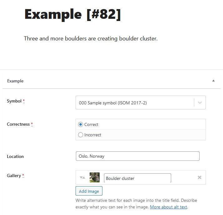
Before adding examples, it is necessary to have a page with a map symbol first. Then you can upload examples. The procedure is as follows
- Don’t bother with the headline. After saving the draft, its number will be added to the example automatically.
- Describe why the example is correct/incorrect. This description will later appear as an explanatory caption below the photo.
- It is necessary to select which map symbol the example applies to and whether it is the correct or incorrect variant of use.
- Enter the nearest city and state in the location field.
- In the gallery field, upload the corresponding photo and edit the title to briefly describe what is shown in the photo.
- It is possible to add more than one photo to one example, which is particularly useful in cases where it is necessary to photograph an object from multiple sides for illustrative purposes.
It is advisable to use a smaller number of examples with a good illustration of the situation rather than a series of poor quality photos. Objects should be clearly identifiable. Blurred photographs, photographs against the sun, with an illegible shadow situation, etc. are not suitable.
If you want to reference the size/height of an object in a photo, the person standing next to the object allows users to easily compare its size/height. This can be useful for illustrating crossable and uncrossable objects.
If you want to upload a map sample, always make sure that the map sample complies with the map specification.
Media metadata
Filling in the metadata for images is important as it makes it easier to search within the Wiki and also for search engines. These fields are available
- Alternative text – if users are unable to load the image, the following information will be displayed instead
- Title – it is important for you to make the image easy to find in the media gallery. Briefly describe what is shown in the image.
- Caption – if you insert an image into a page, this text will appear below it. Describe what is shown, the location of the photo, the author of the photo and the license.
- Description – it’s optional, you can fill detailed description. This section is not public and you can fill it with your personal comments.

System limitations
The Wiki is built under WordPress, which brings a number of advantages and disadvantages. The advantages include a simple user interface and easy maintenance. The disadvantages include some limitations for the Contributor role, such as
- A contributor can only work with drafts. Once the page is published, he loses access to it. However, the editor can return the page to draft state and assign the user.
- Contributor can add images, access the media gallery and fill in metadata. However, he/she does not have the right to delete images either his/her own.
- Media files used in examples or glossary terms are limited to JPG and SVG format.
Discussion
To overcome some of the limitations of the system and to discuss its functionality, data filling and other issues, a private Facebook group omapwiki is available for registered contributors (first register as contributor to Wiki, see above).
The following people and organizations have contributed (in alphabetical order)
Neil Barr, Petr Benc, Christer Carlsson, Ian Cooper, Robert Ditz, Jan Drbal, Gunars Dukste, Ivo Habán, Steven Hale, Aleš Hejna, Zdeněk Janů, Chen Chao, Maxim Kapitonov, Luděk Krtička (project leader), Ainārs Lagzdiņš, Zdeněk Lenhart, Martin Lerjen, Sven Lundbäck, Lok-Hin Ma, Tomáš Novotný, Aleksander Obernikhin, Radim Ondráček, Jan Prášil, David Pustai (programming), Adrian Uppill, Jiří Vištejn.
IOF Map Commission, Lerjen Kartografie, SK Severka Šumperk, WSOC 2022 Kemi-Keminmaa, WOC 2021, Yukon Orienteering Association.